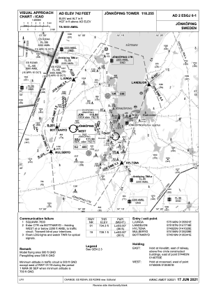
VAC chart of ESGJ
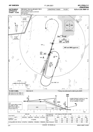
 IAC chart of ESGJ
 ADC chart of ESGJ
 Satellite view of ESGJ

IAC chart of ESGJADC chart of ESGJ
Satellite view of ESGJ
Sorry, we have no imagery here.
Sorry, we have no imagery here.
Sorry, we have no imagery here.
Sorry, we have no imagery here.
Sorry, we have no imagery here.
Sorry, we have no imagery here.


ESGJ - Joenkoeping
Located in Jonkoping, Sweden
ICAO - ESGJ, IATA - JKG
Data provided by AirmateGeneral information
Coordinates: N57°45'30" E14°4'9"
Elevation is 742 feet MSL.
Magnetic variation is +5.0° East View others Airports in Jönköpings län
Operational data
Special qualification required
Current time UTC:
Current local time:
Weather at : ESMV - Hagshult ( 52 km )
METAR: ESMV 200550Z AUTO VRB02KT 0500 FZFG VV002 M01/M01 Q1020
Communications frequencies: [VIEW]
Runways:
| RWY identifier | QFU | Length (ft) | Width (ft) | Surface | LDA (ft) |
| 11 | 114° | 1722 | 82 | GRE | |
| 29 | 294° | 1722 | 82 | GRE | |
| 01 | 18° | 7228 | 148 | ASP | |
| 19 | 198° | 7228 | 148 | ASP |
Airport contact information
Address: Jonkoping Sweden
Other aviation service providers
Aviation club (not for profit)

Prokitor Flight Training
Prokitor Flight Training
henrik.lindberg@prokitor.aero+46761060611
+46761060611
+46761060611
Satellite view of ESGJ
Sorry, we have no imagery here.
Sorry, we have no imagery here.
Sorry, we have no imagery here.
Sorry, we have no imagery here.
Sorry, we have no imagery here.
Sorry, we have no imagery here.