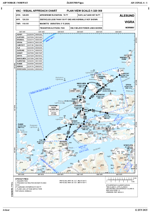
VAC chart of ENAL
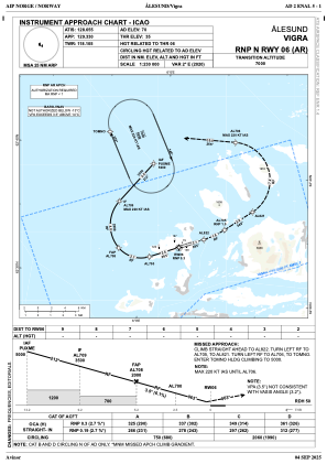
 IAC chart of ENAL
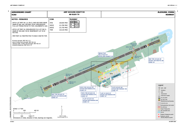
 ADC chart of ENAL
 Satellite view of ENAL
IAC chart of ENALADC chart of ENAL
Satellite view of ENAL
Sorry, we have no imagery here.
Sorry, we have no imagery here.
Sorry, we have no imagery here.
Sorry, we have no imagery here.
Sorry, we have no imagery here.
Sorry, we have no imagery here.


ENAL - Vigra
Located in Aalesund, Norway
ICAO - ENAL, IATA - AES
Data provided by AirmateGeneral information
Coordinates: N62°33'45" E6°7'11"
Elevation is 70 feet MSL.
Magnetic variation is 1.8° East View others Airports in Møre og Romsdal
Operational data
Special qualification required
Current time UTC:
Current local time:
Weather
METAR: ENAL 180820Z 04017KT CAVOK 11/05 Q1025
TAF: TAF ENAL 180500Z 1806/1815 04018KT 9999 FEW012
Communications frequencies: [VIEW]
Runways:
| RWY identifier | QFU | Length (ft) | Width (ft) | Surface | LDA (ft) |
| 06 | 0° | 7592 | 148 | UNK | |
| 24 | 0° | 7592 | 148 | UNK |
Airport contact information
Address: Aalesund Norway
Satellite view of ENAL
Sorry, we have no imagery here.
Sorry, we have no imagery here.
Sorry, we have no imagery here.
Sorry, we have no imagery here.
Sorry, we have no imagery here.
Sorry, we have no imagery here.