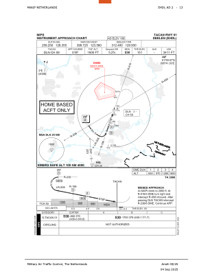
IAC chart of EHDL
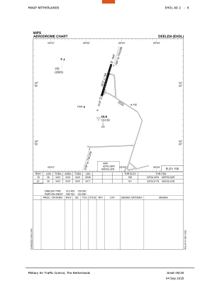
 ADC chart of EHDL
 Satellite view of EHDL
ADC chart of EHDL
Satellite view of EHDL
Sorry, we have no imagery here.
Sorry, we have no imagery here.
Sorry, we have no imagery here.
Sorry, we have no imagery here.
Sorry, we have no imagery here.
Sorry, we have no imagery here.


EHDL - Arnhem/Deelen
Located in Arnhem, Netherlands
ICAO - EHDL, IATA - QAR
Data provided by AirmateGeneral information
Coordinates: N52°3'35" E5°52'19"
Elevation is 158 feet MSL.
Magnetic variation is +1.967° East View others Airports in Gelderland
Operational data
Special qualification required
Current time UTC:
Current local time:
Weather
METAR: EHDL 182355Z AUTO 32003KT 330V040 9999 OVC230 09/05 Q1019 BLU
Communications frequencies: [VIEW]
Runways:
| RWY identifier | QFU | Length (ft) | Width (ft) | Surface | LDA (ft) |
| 01 | 17° | 3431 | 164 | CONC+ASPH | 3411 |
| 19 | 197° | 3431 | 164 | CONC+ASPH | 2536 |
Airport contact information
Address: Arnhem Netherlands
Other aviation service providers
Flight schools

Aviation club (not for profit)

Satellite view of EHDL
Sorry, we have no imagery here.
Sorry, we have no imagery here.
Sorry, we have no imagery here.
Sorry, we have no imagery here.
Sorry, we have no imagery here.
Sorry, we have no imagery here.