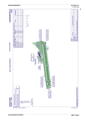
ADC chart of EGSL
 Satellite view of EGSL
Satellite view of EGSL
Sorry, we have no imagery here.
Sorry, we have no imagery here.
Sorry, we have no imagery here.
Sorry, we have no imagery here.
Sorry, we have no imagery here.
Sorry, we have no imagery here.


EGSL - Andrewsfield
Located in Braintree, United Kingdom
ICAO - EGSL, IATA -
Data provided by AirmateGeneral information
Coordinates: N51°53'42" E0°26'57"
Elevation is 286 feet MSL.
View others Airports in England
Operational data
Special qualification required
Current time UTC:
Current local time:
Weather at : EGSS - London Stansted ( 15 km )
METAR: EGSS 180350Z AUTO 33006KT 300V010 9999 OVC017 09/06 Q1021
TAF: TAF AMD EGSS 180345Z 1803/1906 01007KT 9999 BKN016 PROB30 TEMPO 1803/1806 8000 BKN009 BECMG 1822/1901 BKN009 PROB30 TEMPO 1900/1906 4000 BR BKN004
Communications frequencies: [VIEW]
Runways:
| RWY identifier | QFU | Length (ft) | Width (ft) | Surface | LDA (ft) |
| 09L | 85° | 2621 | 59 | Grass | |
| 27R | 265° | 2621 | 59 | Grass | |
| 09R | 85° | 2621 | 59 | Grass | |
| 27L | 265° | 2621 | 59 | Grass |
Airport contact information
Address: Braintree United Kingdom
Satellite view of EGSL
Sorry, we have no imagery here.
Sorry, we have no imagery here.
Sorry, we have no imagery here.
Sorry, we have no imagery here.
Sorry, we have no imagery here.
Sorry, we have no imagery here.