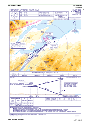
IAC chart of EGPE
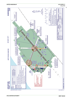
 ADC chart of EGPE
 Satellite view of EGPE

ADC chart of EGPE
Satellite view of EGPE
Sorry, we have no imagery here.
Sorry, we have no imagery here.
Sorry, we have no imagery here.
Sorry, we have no imagery here.
Sorry, we have no imagery here.
Sorry, we have no imagery here.


EGPE - Inverness
Located in Inverness, United Kingdom
ICAO - EGPE, IATA - INV
Data provided by AirmateGeneral information
Coordinates: N57°32'33" W4°2'51"
Elevation is 31 feet MSL.
View others Airports in Scotland
Operational data
Special qualification required
Current time UTC:
Current local time:
Weather
METAR: EGPE 010750Z 23008KT 9999 FEW030 06/04 Q1027
TAF: TAF EGPE 010459Z 0106/0115 24014KT 9999 FEW045
Communications frequencies: [VIEW]
Runways:
| RWY identifier | QFU | Length (ft) | Width (ft) | Surface | LDA (ft) |
| 05 | 49° | 6194 | 148 | ASP | |
| 23 | 229° | 6194 | 148 | ASP | |
| 11 | 110° | 2300 | 59 | UNK | |
| 29 | 290° | 2300 | 59 | UNK |
Airport contact information
Address: Inverness United Kingdom
Handlers

Other aviation service providers
Flight schools

Satellite view of EGPE
Sorry, we have no imagery here.
Sorry, we have no imagery here.
Sorry, we have no imagery here.
Sorry, we have no imagery here.
Sorry, we have no imagery here.
Sorry, we have no imagery here.