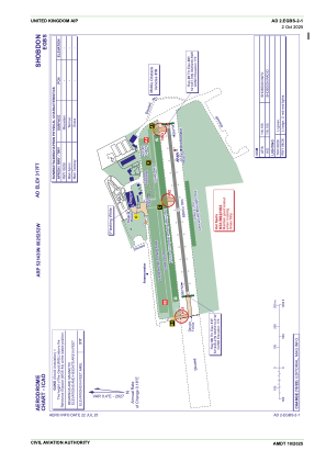
ADC chart of EGBS
 Satellite view of EGBS

Satellite view of EGBS
Sorry, we have no imagery here.
Sorry, we have no imagery here.
Sorry, we have no imagery here.
Sorry, we have no imagery here.
Sorry, we have no imagery here.
Sorry, we have no imagery here.


EGBS - Shobdon
Located in Leominster, United Kingdom
ICAO - EGBS, IATA -
Data provided by AirmateGeneral information
Coordinates: N52°14'30" W2°52'52"
Elevation is 317 feet MSL.
View others Airports in England
Operational data
Special qualification required
Current time UTC:
Current local time:
Weather at : EGWC - Cosford ( 59 km )
METAR: EGWC 282120Z AUTO 08001KT //// ///////// ///// Q////
Communications frequencies: [VIEW]
Runways:
| RWY identifier | QFU | Length (ft) | Width (ft) | Surface | LDA (ft) |
| 08 | 83° | 2743 | 59 | UNK | |
| 26 | 263° | 2743 | 59 | UNK |
Airport contact information
Address: Leominster United Kingdom
Other aviation service providers
Flight schools

Satellite view of EGBS
Sorry, we have no imagery here.
Sorry, we have no imagery here.
Sorry, we have no imagery here.
Sorry, we have no imagery here.
Sorry, we have no imagery here.
Sorry, we have no imagery here.