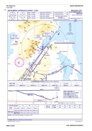
IAC chart of EGAC
 Satellite view of EGAC
Satellite view of EGAC
Sorry, we have no imagery here.
Sorry, we have no imagery here.
Sorry, we have no imagery here.
Sorry, we have no imagery here.
Sorry, we have no imagery here.
Sorry, we have no imagery here.


EGAC - Belfast/City
Located in Belfast, United Kingdom
ICAO - EGAC, IATA - BHD
Data provided by AirmateGeneral information
Coordinates: N54°37'5" W5°52'21"
Elevation is 15 feet MSL.
View others Airports in Northern Ireland
Operational data
Special qualification required
Current time UTC:
Current local time:
Weather
METAR: EGAC 011720Z AUTO 14008KT 9999 NCD 12/02 Q1023
TAF: TAF EGAC 011659Z 0118/0122 14005KT CAVOK TEMPO 0118/0122 15015G25KT
Communications frequencies: [VIEW]
Runways:
| RWY identifier | QFU | Length (ft) | Width (ft) | Surface | LDA (ft) |
| 04 | 35° | 6001 | 148 | ASP | |
| 22 | 215° | 6001 | 148 | ASP |
Airport contact information
Address: Belfast United Kingdom

Satellite view of EGAC
Sorry, we have no imagery here.
Sorry, we have no imagery here.
Sorry, we have no imagery here.
Sorry, we have no imagery here.
Sorry, we have no imagery here.
Sorry, we have no imagery here.