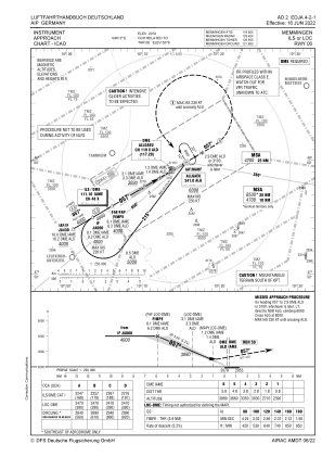
IAC chart of EDJA
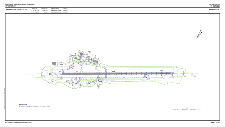
 ADC chart of EDJA
 Satellite view of EDJA

ADC chart of EDJA
Satellite view of EDJA
Sorry, we have no imagery here.
Sorry, we have no imagery here.
Sorry, we have no imagery here.
Sorry, we have no imagery here.
Sorry, we have no imagery here.
Sorry, we have no imagery here.


EDJA - Memmingen
Located in Memmingen, Germany
ICAO - EDJA, IATA - FMM
Data provided by AirmateGeneral information
Coordinates: N47°59'20" E10°14'22"
Elevation is 2079 feet MSL.
Magnetic variation is 2.7000° East View others Airports in Bavaria
Operational data
Special qualification required
Current time UTC:
Current local time:
Weather
METAR: EDJA 200320Z AUTO 06004KT 9999 // OVC089/// 10/04 Q1016
TAF: TAF EDJA 200200Z 2003/2012 04006KT CAVOK BECMG 2009/2011 24007KT
Communications frequencies: [VIEW]
Runways:
| RWY identifier | QFU | Length (ft) | Width (ft) | Surface | LDA (ft) |
| 06 | 59° | 8629 | 148 | ASP | |
| 24 | 239° | 8629 | 148 | ASP |
Airport contact information
Address: Memmingen Germany
Other aviation service providers
Aviation club (not for profit)

Sportfluggruppe Memmingen E.V.
Sportfluggruppe Memmingen E.V.
info@sportfluggruppe-memmingen.de+49833112150
Satellite view of EDJA
Sorry, we have no imagery here.
Sorry, we have no imagery here.
Sorry, we have no imagery here.
Sorry, we have no imagery here.
Sorry, we have no imagery here.
Sorry, we have no imagery here.