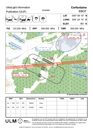
VAC chart of EBCF
 Satellite view of EBCF
Satellite view of EBCF
Sorry, we have no imagery here.
Sorry, we have no imagery here.
Sorry, we have no imagery here.
Sorry, we have no imagery here.
Sorry, we have no imagery here.
Sorry, we have no imagery here.


EBCF - Cerfontaine
Located in Cerfontaine, Belgium
ICAO - EBCF, IATA -
Data provided by AirmateGeneral information
Coordinates: N50°9'10" E4°23'14"
Elevation is 951 feet MSL.
Magnetic variation is 1° East View others Airports in Namur
Operational data
Special qualification required
Current time UTC:
Current local time:
Weather at : EBFS - Florennes ( 21 km )
METAR: EBFS 071725Z AUTO 02008KT 9999 FEW160/// 10/M02 Q1023 BLU
TAF: TAF EBFS 071541Z 0719/0807 04005KT 9999 FEW300 BECMG 0723/0801 11004KT
Communications frequencies: [VIEW]
Runways:
| RWY identifier | QFU | Length (ft) | Width (ft) | Surface | LDA (ft) |
| 11L | 0° | 2618 | 66 | GRASS | |
| 29R | 0° | 2618 | 66 | GRASS | |
| 11R | 0° | 2215 | 98 | GRASS | |
| 29L | 0° | 2215 | 98 | GRASS |
Airport contact information
Address: Cerfontaine Belgium
Satellite view of EBCF
Sorry, we have no imagery here.
Sorry, we have no imagery here.
Sorry, we have no imagery here.
Sorry, we have no imagery here.
Sorry, we have no imagery here.
Sorry, we have no imagery here.