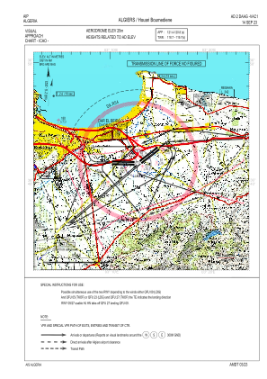
VAC chart of DAAG
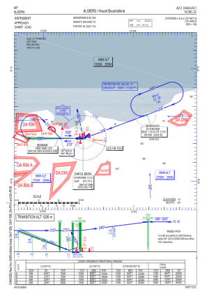
 IAC chart of DAAG
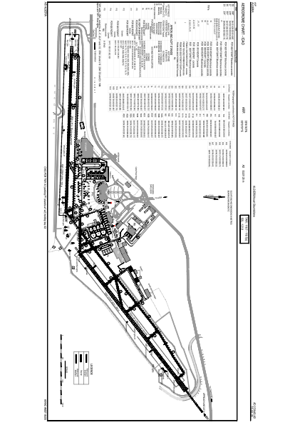
 ADC chart of DAAG
 Satellite view of DAAG
IAC chart of DAAGADC chart of DAAG
Satellite view of DAAG
Sorry, we have no imagery here.
Sorry, we have no imagery here.
Sorry, we have no imagery here.
Sorry, we have no imagery here.
Sorry, we have no imagery here.
Sorry, we have no imagery here.


DAAG - Algiers / Houari Boumediene
Located in Algiers, Algeria
ICAO - DAAG, IATA - ALG
Data provided by AirmateGeneral information
Coordinates: N36°41'40" E3°13'1"
Elevation is 82 feet MSL.
Magnetic variation is 2° East View others Airports in Boumerdès Province
Operational data
Special qualification required
Current time UTC:
Current local time:
Weather
METAR: DAAG 210830Z 01004KT 300V090 9999 FEW026 22/13 Q1020
TAF: TAF DAAG 210500Z 2106/2206 VRB02KT CAVOK BECMG 2109/2111 04010KT BECMG 2118/2120 VRB02KT
Communications frequencies: [VIEW]
Runways:
| RWY identifier | QFU | Length (ft) | Width (ft) | Surface | LDA (ft) |
| 05 | 53° | 11483 | 197 | ASP | |
| 23 | 233° | 11483 | 197 | ASP | |
| 09 | 92° | 11483 | 148 | ASP | |
| 27 | 272° | 11483 | 148 | ASP |
Airport contact information
Address: Algiers Algeria
Satellite view of DAAG
Sorry, we have no imagery here.
Sorry, we have no imagery here.
Sorry, we have no imagery here.
Sorry, we have no imagery here.
Sorry, we have no imagery here.
Sorry, we have no imagery here.