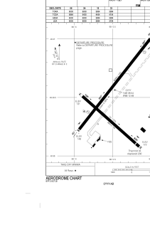
ADC chart of CYYY
 Satellite view of CYYY
Satellite view of CYYY
Sorry, we have no imagery here.
Sorry, we have no imagery here.
Sorry, we have no imagery here.
Sorry, we have no imagery here.
Sorry, we have no imagery here.
Sorry, we have no imagery here.


CYYY - Mont-Joli
Located in , Canada
ICAO - CYYY, IATA - YYY
Data provided by AirmateGeneral information
Coordinates: N48°36'32" W68°12'29"
Elevation is 172 feet MSL.
Magnetic variation is -18.4° East View others Airports in Quebec
Operational data
Special qualification required
Current time UTC:
Current local time:
Weather
METAR: CYYY 170100Z 07008KT 15SM BKN054 10/04 A2977 RMK SC7 SLP083
TAF: TAF CYYY 161940Z 1620/1708 05012G22KT P6SM FEW040 BKN080 BECMG 1622/1624 08012KT FM170700 08012KT P6SM -SHRA BKN020 OVC060 RMK NXT FCST BY 170200Z
Communications frequencies: [VIEW]
Runways:
| RWY identifier | QFU | Length (ft) | Width (ft) | Surface | LDA (ft) |
| 06 | 38° | 6000 | 150 | ASPH | 6000 |
| 24 | 218° | 6000 | 150 | ASPH | 6000 |
| 15 | 132° | 3954 | 150 | ASPH | 3954 |
| 33 | 312° | 3954 | 150 | ASPH | 3724 |
Airport contact information
Address: Canada
Satellite view of CYYY
Sorry, we have no imagery here.
Sorry, we have no imagery here.
Sorry, we have no imagery here.