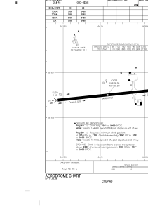
ADC chart of CYGP
 Satellite view of CYGP
Satellite view of CYGP
Sorry, we have no imagery here.
Sorry, we have no imagery here.
Sorry, we have no imagery here.
Sorry, we have no imagery here.
Sorry, we have no imagery here.
Sorry, we have no imagery here.


CYGP - Gaspe (Michel-Pouliot)
Located in , Canada
ICAO - CYGP, IATA - YGP
Data provided by AirmateGeneral information
Coordinates: N48°46'30" W64°28'54"
Elevation is 112 feet MSL.
Magnetic variation is -19.2867° East View others Airports in Quebec
Operational data
Special qualification required
Current time UTC:
Current local time:
Weather
METAR: CYGP 170600Z 28003KT 210V290 15SM BKN054 OVC076 05/M00 A2995 RMK SC7AC1 SLP145
TAF: TAF CYGP 170140Z 1702/1714 VRB03KT P6SM FEW150 FM170300 17005KT P6SM BKN130 FM170600 17007KT P6SM BKN050 BECMG 1711/1713 14010G20KT RMK NXT FCST BY 170800Z
Communications frequencies: [VIEW]
Runways:
| RWY identifier | QFU | Length (ft) | Width (ft) | Surface | LDA (ft) |
| 10 | 84° | 5488 | 150 | ASPH | 5488 |
| 28 | 264° | 5488 | 150 | ASPH | 5488 |
Airport contact information
Address: Canada
Satellite view of CYGP
Sorry, we have no imagery here.
Sorry, we have no imagery here.
Sorry, we have no imagery here.
Sorry, we have no imagery here.
Sorry, we have no imagery here.
Sorry, we have no imagery here.