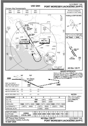
IAC chart of AYPY
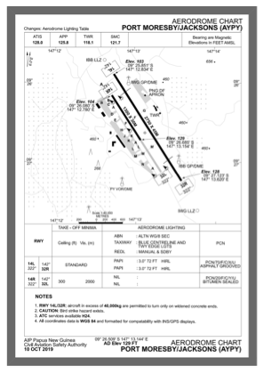
 ADC chart of AYPY
 Satellite view of AYPY
ADC chart of AYPY
Satellite view of AYPY
Sorry, we have no imagery here.
Sorry, we have no imagery here.
Sorry, we have no imagery here.
Sorry, we have no imagery here.
Sorry, we have no imagery here.
Sorry, we have no imagery here.


AYPY - Port Moresby
Located in Port Moresby, Papua New Guinea
ICAO - AYPY, IATA - POM
Data provided by AirmateGeneral information
Coordinates: S9°26'25" E147°13'7"
Elevation is 129 feet MSL.
View others Airports in National Capital District (Port Moresby)
Operational data
Special qualification required
Current time UTC:
Current local time:
Weather
METAR: AYPY 311500Z 02005KT 9999 -SHRA SCT020 BKN030 25/24 Q1009
TAF: TAF AYPY 311045Z 3112/0112 34005KT 9999 -RADZ SCT016 BKN030 INTER 3112/3118 4000 RADZ BKN010 FM010300 30006KT 9999 SCT018 SCT040 PROB30 3119/3121 00000KT 0600 FG
Communications frequencies: [VIEW]
Runways:
| RWY identifier | QFU | Length (ft) | Width (ft) | Surface | LDA (ft) |
| 14R | 149° | 4265 | 98 | ASP | |
| 32L | 329° | 4265 | 98 | ASP | |
| 14L | 149° | 9022 | 148 | ASP | |
| 32R | 329° | 9022 | 148 | ASP |
Airport contact information
Address: Port Moresby Papua New Guinea
Satellite view of AYPY
Sorry, we have no imagery here.
Sorry, we have no imagery here.
Sorry, we have no imagery here.
Sorry, we have no imagery here.
Sorry, we have no imagery here.
Sorry, we have no imagery here.