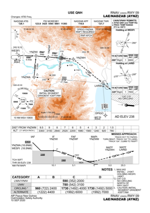
IAC chart of AYNZ
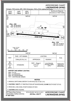
 ADC chart of AYNZ
 Satellite view of AYNZ
ADC chart of AYNZ
Satellite view of AYNZ
Sorry, we have no imagery here.
Sorry, we have no imagery here.
Sorry, we have no imagery here.
Sorry, we have no imagery here.
Sorry, we have no imagery here.
Sorry, we have no imagery here.


AYNZ - Nadzab
Located in Lae, Papua New Guinea
ICAO - AYNZ, IATA - LAE
Data provided by AirmateGeneral information
Coordinates: S6°34'9" E146°43'41"
Elevation is 238 feet MSL.
View others Airports in Morobe
Operational data
Special qualification required
Current time UTC:
Current local time:
Weather
METAR: AYNZ 162300Z 32005KT 9999 FEW020 28/24 Q1010
Communications frequencies: [VIEW]
Runways:
| RWY identifier | QFU | Length (ft) | Width (ft) | Surface | LDA (ft) |
| 09 | 90° | 8002 | 148 | ASP | |
| 27 | 270° | 8002 | 148 | ASP |
Airport contact information
Address: Lae Papua New Guinea
Satellite view of AYNZ
Sorry, we have no imagery here.
Sorry, we have no imagery here.
Sorry, we have no imagery here.
Sorry, we have no imagery here.
Sorry, we have no imagery here.
Sorry, we have no imagery here.