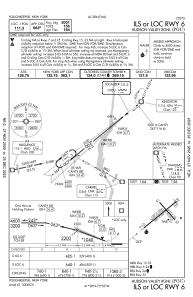
IAC chart of KPOU
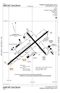
 ADC chart of KPOU
 Satellite view of KPOU

ADC chart of KPOU
Satellite view of KPOU
Sorry, we have no imagery here.
Sorry, we have no imagery here.
Sorry, we have no imagery here.
Sorry, we have no imagery here.
Sorry, we have no imagery here.
Sorry, we have no imagery here.


KPOU - Hudson Valley Rgnl
Located in Poughkeepsie, United States
ICAO - POU, IATA - POU
Data provided by AirmateGeneral information
Coordinates: N41°37'36" W73°53'3"
Elevation is 163 feet MSL.
Magnetic variation is -12° East View others Airports in New York
Operational data
Special qualification required
Current time UTC: 00:45:28
Current local time:
Weather
METAR: KPOU 132353Z 16007KT 10SM CLR 08/M08 A3008 RMK AO2 SLP183 T00781083 10128 20078 53013
TAF: KPOU 132320Z 1400/1424 16007KT P6SM FEW250 FM140300 00000KT P6SM SCT250 TEMPO 1409/1412 BKN020 FM141800 19005KT P6SM FEW250
Communications frequencies: [VIEW]
Runways:
| RWY identifier | QFU | Length (ft) | Width (ft) | Surface | LDA (ft) |
| 06 | 51° | 5001 | 100 | ASPH | 5001 |
| 24 | 231° | 5001 | 100 | ASPH | 4886 |
| 07 | 51° | 1357 | 100 | GRASS | |
| 25 | 231° | 1357 | 100 | GRASS | |
| 15 | 139° | 2743 | 100 | OTHER | 2743 |
| 33 | 319° | 2743 | 100 | OTHER | 2743 |
Airport contact information
Address: Poughkeepsie United States
Satellite view of KPOU
Sorry, we have no imagery here.
Sorry, we have no imagery here.
Sorry, we have no imagery here.
Sorry, we have no imagery here.
Sorry, we have no imagery here.
Sorry, we have no imagery here.