


KMBS - Mbs Intl
Located in Saginaw, United States
ICAO - MBS, IATA - MBS
Data provided by AirmateGeneral information
Coordinates: N43°31'59" W84°4'47"
Elevation is 668 feet MSL.
Magnetic variation is -07° East View others Airports in Michigan
Operational data
Special qualification required
Current time UTC:
Current local time:
Weather
METAR: KMBS 072353Z 32011KT 10SM CLR 13/03 A3009 RMK AO2 SLP191 T01330033 10172 20133 53001
TAF: KMBS 072320Z 0800/0824 32011KT P6SM SCT050 FM080300 27006KT P6SM SKC FM081400 27012KT P6SM SCT040 FM081700 28013G20KT P6SM SCT050
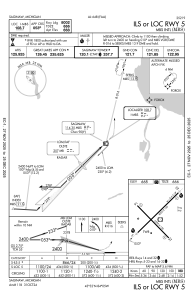
Communications frequencies: [VIEW]
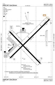
Runways:
| RWY identifier | QFU | Length (ft) | Width (ft) | Surface | LDA (ft) |
| 05 | 46° | 8002 | 150 | ASPH | 8002 |
| 23 | 226° | 8002 | 150 | ASPH | 8002 |
| 14 | 136° | 6399 | 150 | ASPH | 6399 |
| 32 | 316° | 6399 | 150 | ASPH | 6399 |
Airport contact information
Address: Saginaw United States