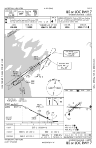
IAC chart of KART
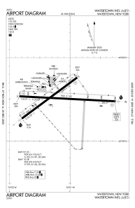
 ADC chart of KART
 Satellite view of KART
ADC chart of KART
Satellite view of KART
Sorry, we have no imagery here.
Sorry, we have no imagery here.
Sorry, we have no imagery here.
Sorry, we have no imagery here.
Sorry, we have no imagery here.
Sorry, we have no imagery here.


KART - Watertown Intl
Located in Watertown, United States
ICAO - ART, IATA - ART
Data provided by AirmateGeneral information
Coordinates: N43°59'31" W76°1'10"
Elevation is 330 feet MSL.
Magnetic variation is -12° East View others Airports in New York
Operational data
Special qualification required
Current time UTC: 00:53:20
Current local time:
Weather
METAR: KART 132356Z AUTO 05005KT 10SM CLR 04/M03 A3000 RMK AO2 SLP163 T00441033 10111 20044 53010
TAF: KART 132320Z 1400/1424 04004KT P6SM BKN250 FM140300 00000KT P6SM FEW250 FM141400 16004KT P6SM SCT250 FM141800 18006KT P6SM FEW250
Communications frequencies: [VIEW]
Runways:
| RWY identifier | QFU | Length (ft) | Width (ft) | Surface | LDA (ft) |
| 07 | 53° | 4999 | 150 | ASPH | 4784 |
| 25 | 233° | 4999 | 150 | ASPH | 4999 |
| 10 | 93° | 7001 | 150 | ASPH | 7001 |
| 28 | 273° | 7001 | 150 | ASPH | 7001 |
Airport contact information
Address: Watertown United States
