ADC chart of HLWD
 Satellite view of HLWD
Satellite view of HLWD
Sorry, we have no imagery here.
Sorry, we have no imagery here.
Sorry, we have no imagery here.
Sorry, we have no imagery here.
Sorry, we have no imagery here.


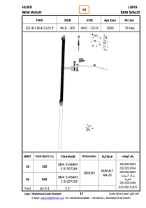
HLWD - Beni Walid
Located in Bani Walid, Libyan Arab Jamahiriya
ICAO - , IATA - QBL
Data provided by AirmateGeneral information
Coordinates: N31°44'23" E13°57'14"
Elevation is 1000 feet MSL.
Magnetic variation is 3° East View others Airports in Misurata District
Operational data
Special qualification required
Current time UTC: 20:05:41
Current local time:
Weather at : - ( 0 km )
METAR: UUYY 142001Z 18005MPS 3700 -RA BR OVC005 05/05 Q0987 R18/29//51 NOSIG RMK QFE732/0976
Communications frequencies: [VIEW]
Runways:
| RWY identifier | QFU | Length (ft) | Width (ft) | Surface | LDA (ft) |
| 18 | 0° | 5906 | 148 | ASPH | |
| 36 | 0° | 5906 | 148 | ASPH |
Airport contact information
Address: Bani Walid Libyan Arab Jamahiriya
Satellite view of HLWD
Sorry, we have no imagery here.
Sorry, we have no imagery here.
Sorry, we have no imagery here.
Sorry, we have no imagery here.
Sorry, we have no imagery here.