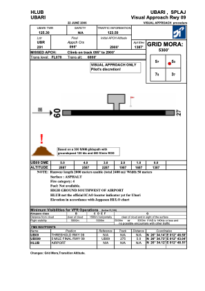
VAC chart of HLUB
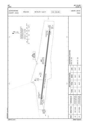
 ADC chart of HLUB
 Satellite view of HLUB
ADC chart of HLUB
Satellite view of HLUB
Sorry, we have no imagery here.
Sorry, we have no imagery here.
Sorry, we have no imagery here.
Sorry, we have no imagery here.
Sorry, we have no imagery here.
Sorry, we have no imagery here.


HLUB - Ubari
Located in Ubari, Libyan Arab Jamahiriya
ICAO - , IATA - QUB
Data provided by AirmateGeneral information
Coordinates: N26°34'3" E12°49'23"
Elevation is 1528 feet MSL.
Magnetic variation is 3° East View others Airports in Wadi Al Shatii District
Operational data
Special qualification required
Current time UTC: 14:51:51
Current local time:
Communications frequencies: [VIEW]
Runways:
| RWY identifier | QFU | Length (ft) | Width (ft) | Surface | LDA (ft) |
| 09 | 97° | 8363 | 94 | ASPH | |
| 27 | 277° | 8363 | 94 | ASPH |
Airport contact information
Address: Ubari Libyan Arab Jamahiriya
Satellite view of HLUB
Sorry, we have no imagery here.
Sorry, we have no imagery here.
Sorry, we have no imagery here.
Sorry, we have no imagery here.
Sorry, we have no imagery here.
Sorry, we have no imagery here.