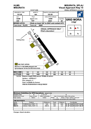
VAC chart of HLMS
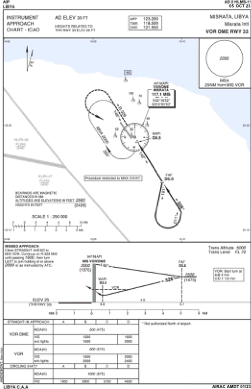
 IAC chart of HLMS
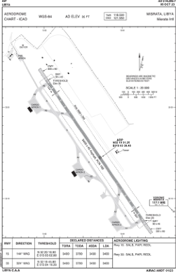
 ADC chart of HLMS
 Satellite view of HLMS
IAC chart of HLMSADC chart of HLMS
Satellite view of HLMS
Sorry, we have no imagery here.
Sorry, we have no imagery here.
Sorry, we have no imagery here.
Sorry, we have no imagery here.
Sorry, we have no imagery here.
Sorry, we have no imagery here.


HLMS - Misrata International
Located in Misurata, Libyan Arab Jamahiriya
ICAO - , IATA - MRA
Data provided by AirmateGeneral information
Coordinates: N32°19'31" E15°3'39"
Elevation is 35 feet MSL.
Magnetic variation is 3° East View others Airports in Misurata District
Operational data
Special qualification required
Current time UTC: 20:05:41
Current local time:
Weather at : - ( 0 km )
METAR: CYET 142002Z AUTO 30003KT 260V350 9SM OVC020 M10/M15 A2961 RMK SLP090
Communications frequencies: [VIEW]
Runways:
| RWY identifier | QFU | Length (ft) | Width (ft) | Surface | LDA (ft) |
| 15 | 146° | 11117 | 144 | ASPH | |
| 33 | 326° | 11117 | 144 | ASPH |
Airport contact information
Address: Misurata Libyan Arab Jamahiriya
Satellite view of HLMS
Sorry, we have no imagery here.
Sorry, we have no imagery here.
Sorry, we have no imagery here.
Sorry, we have no imagery here.
Sorry, we have no imagery here.
Sorry, we have no imagery here.