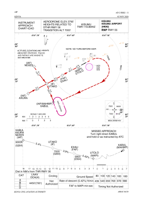
IAC chart of HKKI
 Satellite view of HKKI

Satellite view of HKKI
Sorry, we have no imagery here.
Sorry, we have no imagery here.
Sorry, we have no imagery here.
Sorry, we have no imagery here.
Sorry, we have no imagery here.
Sorry, we have no imagery here.


HKKI - Kisumu
Located in Kisumu, Kenya
ICAO - HKKI, IATA - KIS
Data provided by AirmateGeneral information
Coordinates: S0°5'9" E34°43'44"
Elevation is 3795 feet MSL.
Magnetic variation is 1° East View others Airports in Nyanza Province
Operational data
Special qualification required
Current time UTC: 14:21:24
Current local time:
Weather
METAR: HKKI 241400Z 23011KT 9999 FEW026CB SCT290 29/14 Q1015
TAF: TAF HKKI 241100Z 2412/2518 22010KT 9999 FEW026CB SCT027 PROB30 TEMPO 2413/2417 -TSRA FEW020CB SCT021 BKN080 BECMG 2420/2423 06005KT CAVOK BECMG 2508/2511 22010KT 9999 FEW025CB SCT026 PROB30 TEMPO 2513/2517 -TSRA FEW020CB SCT021 BKN080
Communications frequencies: [VIEW]
Runways:
| RWY identifier | QFU | Length (ft) | Width (ft) | Surface | LDA (ft) |
| 06 | 62° | 9350 | 146 | ASPH | 9843 |
| 24 | 242° | 9350 | 146 | ASPH | 10312 |
Airport contact information
Address: Kisumu Kenya
Satellite view of HKKI
Sorry, we have no imagery here.
Sorry, we have no imagery here.
Sorry, we have no imagery here.
Sorry, we have no imagery here.
Sorry, we have no imagery here.
Sorry, we have no imagery here.