ADC chart of 1H4
 Satellite view of 1H4
Satellite view of 1H4
Sorry, we have no imagery here.
Sorry, we have no imagery here.
Sorry, we have no imagery here.
Sorry, we have no imagery here.
Sorry, we have no imagery here.
Sorry, we have no imagery here.


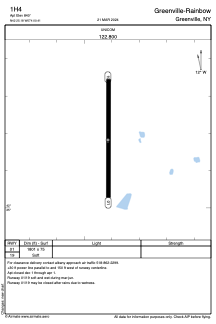
1H4 - Greenville-Rainbow
Located in Greenville, United States
ICAO - 1H4, IATA -
Data provided by AirmateGeneral information
Coordinates: N42°25'11" W74°0'25"
Elevation is 840 feet MSL.
Magnetic variation is -14° East View others Airports in New York
Operational data
Special qualification required
Current time UTC: 00:41:56
Current local time:
Weather at : KALB - Albany Intl ( 40 km )
METAR: KALB 132351Z 16006KT 10SM BKN250 11/M05 A3005 RMK AO2 SLP177 T01061050 10128 20100 53010
TAF: KALB 132320Z 1400/1424 16005KT P6SM BKN250 FM140700 16004KT P6SM FEW250 FM141600 17007KT P6SM FEW250
Communications frequencies: [VIEW]
Runways:
| RWY identifier | QFU | Length (ft) | Width (ft) | Surface | LDA (ft) |
| 01 | 360° | 1801 | 75 | GRASS | |
| 19 | 180° | 1801 | 75 | GRASS |
Airport contact information
Address: Greenville United States
Satellite view of 1H4
Sorry, we have no imagery here.
Sorry, we have no imagery here.
Sorry, we have no imagery here.
Sorry, we have no imagery here.
Sorry, we have no imagery here.
Sorry, we have no imagery here.