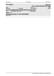
ADC chart of YTHY
 Satellite view of YTHY
Satellite view of YTHY
Sorry, we have no imagery here.
Sorry, we have no imagery here.
Sorry, we have no imagery here.
Sorry, we have no imagery here.
Sorry, we have no imagery here.
Sorry, we have no imagery here.


YTHY - Thylungra
Located in Eromanga, Australia
ICAO - YTHY, IATA - TYG
Data provided by AirmateGeneral information
Coordinates: S26°5'34" E143°27'5"
Elevation is 540 feet MSL.
Magnetic variation is 8° East View others Airports in Queensland
Operational data
Special qualification required
Current time UTC:
Current local time:
Weather at : - ( 0 km )
METAR: YAMB 021911Z AUTO 21004KT 9999 // FEW013 OVC028 20/19 Q1007
Communications frequencies: [VIEW]
Runways:
| RWY identifier | QFU | Length (ft) | Width (ft) | Surface | LDA (ft) |
| 18 | 191° | 3543 | 0 | S | |
| 36 | 0° | 3543 | 0 | S | |
| 36 | 11° | 0 | 0 | UNK |
Airport contact information
Address: Eromanga Australia
Satellite view of YTHY
Sorry, we have no imagery here.
Sorry, we have no imagery here.
Sorry, we have no imagery here.
Sorry, we have no imagery here.
Sorry, we have no imagery here.
Sorry, we have no imagery here.