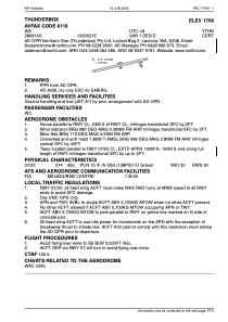
ADC chart of YTHN
 Satellite view of YTHN
Satellite view of YTHN
Sorry, we have no imagery here.
Sorry, we have no imagery here.
Sorry, we have no imagery here.
Sorry, we have no imagery here.
Sorry, we have no imagery here.
Sorry, we have no imagery here.


YTHN - Thunderbox
Located in Leinster, Australia
ICAO - , IATA -
Data provided by AirmateGeneral information
Coordinates: S28°9'14" E120°56'21"
Elevation is 1705 feet MSL.
View others Airports in Queensland
Operational data
Special qualification required
Current time UTC:
Current local time:
Weather at : - ( 0 km )
METAR: YLHI 022135Z AUTO 13003KT 9999 -SHRA BKN017 OVC044 21/19 Q1008
Communications frequencies: [VIEW]
Runways:
| RWY identifier | QFU | Length (ft) | Width (ft) | Surface | LDA (ft) |
| 07 | 75° | 6562 | 98 | UNK | |
| 25 | 255° | 6562 | 98 | UNK |
Airport contact information
Address: Leinster Australia
Satellite view of YTHN
Sorry, we have no imagery here.
Sorry, we have no imagery here.
Sorry, we have no imagery here.
Sorry, we have no imagery here.
Sorry, we have no imagery here.
Sorry, we have no imagery here.