ADC chart of YSTL
 Satellite view of YSTL
Satellite view of YSTL
Sorry, we have no imagery here.
Sorry, we have no imagery here.
Sorry, we have no imagery here.
Sorry, we have no imagery here.
Sorry, we have no imagery here.
Sorry, we have no imagery here.


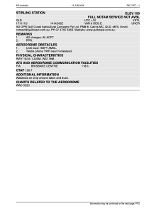
YSTL - Stirling Station
Located in , Australia
ICAO - , IATA -
Data provided by AirmateGeneral information
Coordinates: S17°11'11" E141°42'42"
Elevation is 150 feet MSL.
View others Airports in Queensland
Operational data
Special qualification required
Current time UTC:
Current local time:
Weather at : - ( 0 km )
METAR: KJXI 022015Z AUTO 17010G19KT 10SM SCT029 27/18 A2964 RMK AO2 T02670181
Communications frequencies: [VIEW]
Runways:
| RWY identifier | QFU | Length (ft) | Width (ft) | Surface | LDA (ft) |
| 16 | 0° | 3937 | 59 | UNK | |
| 34 | 0° | 3937 | 59 | UNK |
Airport contact information
Address: Australia
Satellite view of YSTL
Sorry, we have no imagery here.
Sorry, we have no imagery here.
Sorry, we have no imagery here.
Sorry, we have no imagery here.
Sorry, we have no imagery here.
Sorry, we have no imagery here.