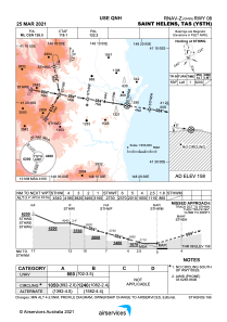
IAC chart of YSTH
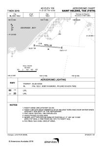
 ADC chart of YSTH
 Satellite view of YSTH
ADC chart of YSTH
Satellite view of YSTH
Sorry, we have no imagery here.
Sorry, we have no imagery here.
Sorry, we have no imagery here.
Sorry, we have no imagery here.
Sorry, we have no imagery here.
Sorry, we have no imagery here.


YSTH - Saint Helens
Located in Saint Helens, Australia
ICAO - YSTH, IATA - HLS
Data provided by AirmateGeneral information
Coordinates: S41°20'12" E148°16'55"
Elevation is 158 feet MSL.
View others Airports in Tasmania
Operational data
Special qualification required
Current time UTC:
Current local time:
Weather at : - ( 0 km )
METAR: PKWA 091620Z AUTO 07010G15KT 10SM SCT020 SCT028 27/23 A2982 RMK AO2 T02700232
Communications frequencies: [VIEW]
Runways:
| RWY identifier | QFU | Length (ft) | Width (ft) | Surface | LDA (ft) |
| 08 | 94° | 3510 | 98 | S | |
| 26 | 274° | 3510 | 98 | S |
Airport contact information
Address: Saint Helens Australia
Satellite view of YSTH
Sorry, we have no imagery here.
Sorry, we have no imagery here.
Sorry, we have no imagery here.
Sorry, we have no imagery here.
Sorry, we have no imagery here.
Sorry, we have no imagery here.