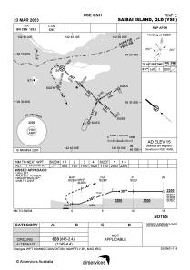
IAC chart of YSII
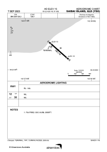
 ADC chart of YSII
 Satellite view of YSII
ADC chart of YSII
Satellite view of YSII
Sorry, we have no imagery here.
Sorry, we have no imagery here.
Sorry, we have no imagery here.
Sorry, we have no imagery here.
Sorry, we have no imagery here.


YSII - Saibai Island
Located in Cairns, Australia
ICAO - YSII, IATA - SBR
Data provided by AirmateGeneral information
Coordinates: S9°22'42" E142°37'30"
Elevation is 15 feet MSL.
View others Airports in Queensland
Operational data
Special qualification required
Current time UTC:
Current local time:
Weather at : - ( 0 km )
METAR: KJXI 030035Z AUTO 19006KT 10SM RA SCT001 SCT005 SCT036 25/19 A2962 RMK AO2 T02500194
Communications frequencies: [VIEW]
Runways:
| RWY identifier | QFU | Length (ft) | Width (ft) | Surface | LDA (ft) |
| 12 | 132° | 2461 | 59 | N | |
| 30 | 312° | 2461 | 59 | N |
Airport contact information
Address: Cairns Australia
Satellite view of YSII
Sorry, we have no imagery here.
Sorry, we have no imagery here.
Sorry, we have no imagery here.
Sorry, we have no imagery here.
Sorry, we have no imagery here.