ADC chart of YRTP
 Satellite view of YRTP
Satellite view of YRTP
Sorry, we have no imagery here.
Sorry, we have no imagery here.
Sorry, we have no imagery here.
Sorry, we have no imagery here.
Sorry, we have no imagery here.
Sorry, we have no imagery here.


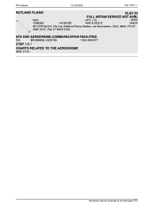
YRTP - Rutland Plains
Located in Normanton, Australia
ICAO - YRTP, IATA - RTP
Data provided by AirmateGeneral information
Coordinates: S15°38'42" E141°50'41"
Elevation is 50 feet MSL.
Magnetic variation is 5° East View others Airports in Queensland
Operational data
Special qualification required
Current time UTC:
Current local time:
Weather at : - ( 0 km )
METAR: TXKF 022155Z 05009KT 9999 SCT013 BKN030 BKN300 20/18 Q1026
Communications frequencies: [VIEW]
Runways:
| RWY identifier | QFU | Length (ft) | Width (ft) | Surface | LDA (ft) |
| 12 | 0° | 3205 | 0 | C | |
| 30 | 0° | 3205 | 0 | C |
Airport contact information
Address: Normanton Australia
Satellite view of YRTP
Sorry, we have no imagery here.
Sorry, we have no imagery here.
Sorry, we have no imagery here.
Sorry, we have no imagery here.
Sorry, we have no imagery here.
Sorry, we have no imagery here.