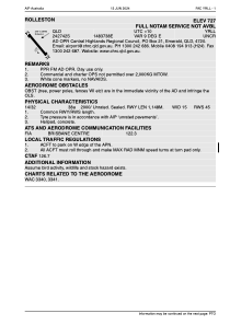
ADC chart of YRLL
 Satellite view of YRLL
Satellite view of YRLL
Sorry, we have no imagery here.
Sorry, we have no imagery here.
Sorry, we have no imagery here.
Sorry, we have no imagery here.
Sorry, we have no imagery here.
Sorry, we have no imagery here.


YRLL - Rolleston
Located in Rolleston, Australia
ICAO - YRLL, IATA -
Data provided by AirmateGeneral information
Coordinates: S24°27'37" E148°37'38"
Elevation is 730 feet MSL.
Magnetic variation is 9° East View others Airports in Queensland
Operational data
Special qualification required
Current time UTC:
Current local time:
Weather at : - ( 0 km )
METAR: YBHM 022206Z AUTO 33007KT 9999 VCTS FEW018 SCT021 BKN033 26/25 Q1010 RETS RERA
Communications frequencies: [VIEW]
Runways:
| RWY identifier | QFU | Length (ft) | Width (ft) | Surface | LDA (ft) |
| 14 | 0° | 3766 | 49 | UNK | |
| 32 | 0° | 3766 | 49 | UNK |
Airport contact information
Address: Rolleston Australia
Satellite view of YRLL
Sorry, we have no imagery here.
Sorry, we have no imagery here.
Sorry, we have no imagery here.
Sorry, we have no imagery here.
Sorry, we have no imagery here.
Sorry, we have no imagery here.