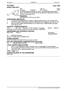
ADC chart of YPLU
 Satellite view of YPLU
Satellite view of YPLU
Sorry, we have no imagery here.
Sorry, we have no imagery here.
Sorry, we have no imagery here.
Sorry, we have no imagery here.
Sorry, we have no imagery here.
Sorry, we have no imagery here.


YPLU - Plutonic
Located in Plutonic Village, Australia
ICAO - YPLU, IATA -
Data provided by AirmateGeneral information
Coordinates: S25°18'60" E119°25'24"
Elevation is 1896 feet MSL.
View others Airports in Western Australia
Operational data
Special qualification required
Current time UTC:
Current local time:
Weather at : - ( 0 km )
METAR: URMO 101717Z 09002MPS 4800 -SHSN SCT010 OVC050CB 00/M00 Q1013 R09/290350 TEMPO 0300 +SHSN BKN002 BKN020CB RMK QFE716/0955
Communications frequencies: [VIEW]
Runways:
| RWY identifier | QFU | Length (ft) | Width (ft) | Surface | LDA (ft) |
| 07 | 66° | 6795 | 98 | X | |
| 25 | 246° | 6795 | 98 | X |
Airport contact information
Address: Plutonic Village Australia
Satellite view of YPLU
Sorry, we have no imagery here.
Sorry, we have no imagery here.
Sorry, we have no imagery here.
Sorry, we have no imagery here.
Sorry, we have no imagery here.
Sorry, we have no imagery here.