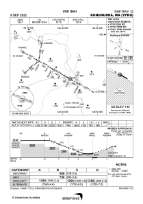
IAC chart of YPKU
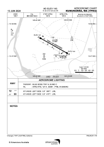
 ADC chart of YPKU
 Satellite view of YPKU
ADC chart of YPKU
Satellite view of YPKU
Sorry, we have no imagery here.
Sorry, we have no imagery here.
Sorry, we have no imagery here.
Sorry, we have no imagery here.
Sorry, we have no imagery here.
Sorry, we have no imagery here.


YPKU - Kununurra
Located in Kununurra, Australia
ICAO - YPKU, IATA - KNX
Data provided by AirmateGeneral information
Coordinates: S15°46'41" E128°42'27"
Elevation is 145 feet MSL.
View others Airports in Western Australia
Operational data
Special qualification required
Current time UTC:
Current local time:
Weather
METAR: YPKU 080900Z AUTO 13005KT 9999 // NCD 33/22 Q1010
TAF: TAF AMD YPKU 080717Z 0807/0820 11010KT 9999 FEW050 FM081200 VRB03KT CAVOK
Communications frequencies: [VIEW]
Runways:
| RWY identifier | QFU | Length (ft) | Width (ft) | Surface | LDA (ft) |
| 12 | 120° | 6001 | 98 | ASP | |
| 30 | 300° | 6001 | 98 | ASP |
Airport contact information
Address: Kununurra Australia
Other aviation service providers
Flight schools

Australian Helicopter Academy
Australian Helicopter Academy
admin@australianhelicopteracademy.com.au+61891681110
Satellite view of YPKU
Sorry, we have no imagery here.
Sorry, we have no imagery here.
Sorry, we have no imagery here.
Sorry, we have no imagery here.
Sorry, we have no imagery here.
Sorry, we have no imagery here.