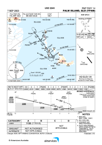
IAC chart of YPAM
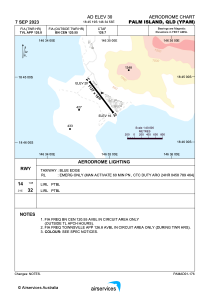
 ADC chart of YPAM
 Satellite view of YPAM
ADC chart of YPAM
Satellite view of YPAM
Sorry, we have no imagery here.
Sorry, we have no imagery here.
Sorry, we have no imagery here.
Sorry, we have no imagery here.
Sorry, we have no imagery here.
Sorry, we have no imagery here.


YPAM - Palm Island
Located in Palm Island, Australia
ICAO - YPAM, IATA - PMK
Data provided by AirmateGeneral information
Coordinates: S18°45'19" E146°34'53"
Elevation is 30 feet MSL.
View others Airports in Queensland
Operational data
Special qualification required
Current time UTC:
Current local time:
Weather at : YBTL - Townsville / Townsville Intl ( 59 km )
METAR: YBTL 022000Z AUTO 00000KT 9999 // NCD 25/25 Q1008
TAF: TAF YBTL 021720Z 0218/0318 34007KT 9999 -SHRA FEW010 SCT015 FM030000 01012KT 9999 -SHRA FEW017 SCT040 FM030900 34006KT 9999 -SHRA SCT017 TEMPO 0218/0223 9999 BKN010 INTER 0218/0221 VRB15G25KT 2000 SHRA BKN014 SCT025TCU INTER 0301/0318 VRB15G25KT 2000 SHRA BKN015 SCT025TCU TEMPO 0310/0318 9999 BKN010 PROB30 TEMPO 0218/0221 VRB20G30KT 0500 +TSRA BKN005 SCT018CB PROB30 TEMPO 0302/0309 VRB20G30KT 0500 +TSRA BKN012 SCT025CB
Communications frequencies: [VIEW]
Runways:
| RWY identifier | QFU | Length (ft) | Width (ft) | Surface | LDA (ft) |
| 14 | 143° | 3724 | 59 | COP | |
| 32 | 323° | 3724 | 59 | COP |
Airport contact information
Address: Palm Island Australia
Satellite view of YPAM
Sorry, we have no imagery here.
Sorry, we have no imagery here.
Sorry, we have no imagery here.
Sorry, we have no imagery here.
Sorry, we have no imagery here.
Sorry, we have no imagery here.