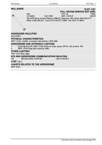
ADC chart of YNUL
 Satellite view of YNUL
Satellite view of YNUL
Sorry, we have no imagery here.
Sorry, we have no imagery here.
Sorry, we have no imagery here.
Sorry, we have no imagery here.
Sorry, we have no imagery here.
Sorry, we have no imagery here.


YNUL - Nullagine
Located in Newman, Australia
ICAO - YNUL, IATA - NLL
Data provided by AirmateGeneral information
Coordinates: S21°54'42" E120°11'55"
Elevation is 1251 feet MSL.
Magnetic variation is 1° East View others Airports in Western Australia
Operational data
Special qualification required
Current time UTC:
Current local time:
Weather at : - ( 0 km )
METAR: KSUE 070057Z AUTO 19016G20KT 10SM CLR 03/M04 A2985 RMK AO2 SLP115 T00281039
Communications frequencies: [VIEW]
Runways:
| RWY identifier | QFU | Length (ft) | Width (ft) | Surface | LDA (ft) |
| 14 | 0° | 5315 | 98 | SU | |
| 32 | 0° | 5315 | 98 | SU |
Airport contact information
Address: Newman Australia
Satellite view of YNUL
Sorry, we have no imagery here.
Sorry, we have no imagery here.
Sorry, we have no imagery here.
Sorry, we have no imagery here.
Sorry, we have no imagery here.
Sorry, we have no imagery here.