


YNAP - Nappa Merrie
Located in Leigh Creek, Australia
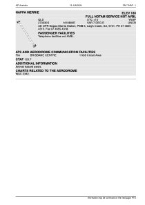
ICAO - YNAP, IATA - NMR
Data provided by AirmateGeneral information
Coordinates: S27°32'56" E141°9'30"
Elevation is 185 feet MSL.
Magnetic variation is 7° East View others Airports in Queensland
Operational data
Special qualification required
Current time UTC:
Current local time:
Weather at : - ( 0 km )
METAR: CYOO 022042Z AUTO 10017G25KT 3SM -SN -FZUP BKN009 OVC033 M01/M01 A3006 RMK ICE PRESFR PCPN 2.5MM PAST HR SLP189
Communications frequencies: [VIEW]
Runways:
| RWY identifier | QFU | Length (ft) | Width (ft) | Surface | LDA (ft) |
| 14 | 0° | 3474 | 0 | C | |
| 32 | 0° | 3474 | 0 | C |
Airport contact information
Address: Leigh Creek Australia