


YMWA - Mullewa
Located in Mullewa, Australia
ICAO - YMWA, IATA - MXU
Data provided by AirmateGeneral information
Coordinates: S28°28'25" E115°31'4"
Elevation is 950 feet MSL.
Magnetic variation is -1° East View others Airports in Western Australia
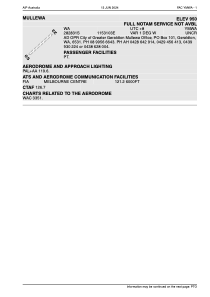
Operational data
Special qualification required
Current time UTC:
Current local time:
Weather at : - ( 0 km )
METAR: PAGM 112110Z AUTO 07022G28KT 10SM -RA SCT030 OVC038 01/M01 A2905 RMK AO2 PK WND 07028/2108 UPB2057E2059 P0000 FZRANO
Communications frequencies: [VIEW]
Runways:
| RWY identifier | QFU | Length (ft) | Width (ft) | Surface | LDA (ft) |
| 05 | 0° | 4721 | 0 | X | |
| 23 | 0° | 4721 | 0 | X |
Airport contact information
Address: Mullewa Australia