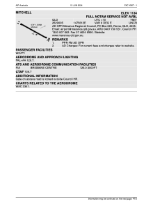
ADC chart of YMIT
 Satellite view of YMIT
Satellite view of YMIT
Sorry, we have no imagery here.
Sorry, we have no imagery here.
Sorry, we have no imagery here.
Sorry, we have no imagery here.
Sorry, we have no imagery here.
Sorry, we have no imagery here.


YMIT - Mitchell
Located in Mitchell, Australia
ICAO - YMIT, IATA - MTQ
Data provided by AirmateGeneral information
Coordinates: S26°29'11" E147°56'39"
Elevation is 1144 feet MSL.
Magnetic variation is 9° East View others Airports in Queensland
Operational data
Special qualification required
Current time UTC:
Current local time:
Weather at : - ( 0 km )
METAR: UIUU 022102Z 33008G14MPS 9999 NSC 05/M04 Q1008 R26/CLRD60 NOSIG RMK QFE712/0950
Communications frequencies: [VIEW]
Runways:
| RWY identifier | QFU | Length (ft) | Width (ft) | Surface | LDA (ft) |
| 11 | 113° | 4675 | 98 | ASP | |
| 29 | 293° | 4675 | 98 | ASP | |
| 28 | 294° | 4677 | 101 | ASPH | |
| 10 | 114° | 4677 | 101 | ASPH |
Airport contact information
Address: Mitchell Australia
Satellite view of YMIT
Sorry, we have no imagery here.
Sorry, we have no imagery here.
Sorry, we have no imagery here.
Sorry, we have no imagery here.
Sorry, we have no imagery here.
Sorry, we have no imagery here.