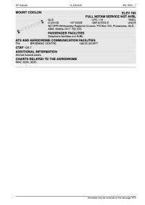
ADC chart of YMCL
 Satellite view of YMCL
Satellite view of YMCL
Sorry, we have no imagery here.
Sorry, we have no imagery here.
Sorry, we have no imagery here.
Sorry, we have no imagery here.
Sorry, we have no imagery here.
Sorry, we have no imagery here.


YMCL - Mount Coolon
Located in Proserpine, Australia
ICAO - YMCL, IATA -
Data provided by AirmateGeneral information
Coordinates: S21°23'13" E147°19'56"
Elevation is 239 feet MSL.
View others Airports in Queensland
Operational data
Special qualification required
Current time UTC:
Current local time:
Weather at : - ( 0 km )
METAR: PPIZ 021956Z AUTO 36006KT 10SM OVC001 M22/M24 A2982 RMK AO2 SLP103 T12171244 FZRANO
Communications frequencies: [VIEW]
Runways:
| RWY identifier | QFU | Length (ft) | Width (ft) | Surface | LDA (ft) |
| 06 | 0° | 2919 | 0 | C | |
| 24 | 0° | 2919 | 0 | C |
Airport contact information
Address: Proserpine Australia
Satellite view of YMCL
Sorry, we have no imagery here.
Sorry, we have no imagery here.
Sorry, we have no imagery here.
Sorry, we have no imagery here.
Sorry, we have no imagery here.
Sorry, we have no imagery here.