IAC chart of YKKG
 ADC chart of YKKG
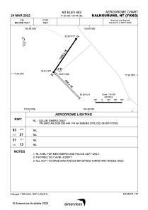
 Satellite view of YKKG
ADC chart of YKKG
Satellite view of YKKG
Sorry, we have no imagery here.
Sorry, we have no imagery here.
Sorry, we have no imagery here.
Sorry, we have no imagery here.
Sorry, we have no imagery here.
Sorry, we have no imagery here.


YKKG - Kalkgurung
Located in Wave Hill, Australia
ICAO - YKKG, IATA - KFG
Data provided by AirmateGeneral information
Coordinates: S17°25'55" E130°48'29"
Elevation is 647 feet MSL.
View others Airports in Northern Territory
Operational data
Special qualification required
Current time UTC:
Current local time:
Weather at : - ( 0 km )
METAR: SCIE 050932Z AUTO 02008KT 9999 OVC012/// 14/12 Q1013
Communications frequencies: [VIEW]
Runways:
| RWY identifier | QFU | Length (ft) | Width (ft) | Surface | LDA (ft) |
| 13 | 135° | 3136 | 59 | GVL | |
| 31 | 315° | 3136 | 59 | GVL | |
| 03 | 34° | 4101 | 59 | ASP | |
| 21 | 214° | 4101 | 59 | ASP |
Airport contact information
Address: Wave Hill Australia
Satellite view of YKKG
Sorry, we have no imagery here.
Sorry, we have no imagery here.
Sorry, we have no imagery here.
Sorry, we have no imagery here.
Sorry, we have no imagery here.
Sorry, we have no imagery here.