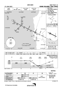
IAC chart of YKII
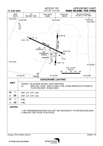
 ADC chart of YKII
 Satellite view of YKII
ADC chart of YKII
Satellite view of YKII
Sorry, we have no imagery here.
Sorry, we have no imagery here.
Sorry, we have no imagery here.
Sorry, we have no imagery here.
Sorry, we have no imagery here.
Sorry, we have no imagery here.


YKII - King Island
Located in Currie, Australia
ICAO - YKII, IATA - KNS
Data provided by AirmateGeneral information
Coordinates: S39°52'39" E143°52'42"
Elevation is 132 feet MSL.
View others Airports in Tasmania
Operational data
Special qualification required
Current time UTC:
Current local time:
Weather at : - ( 0 km )
METAR: ZMUB 092200Z VRB02MPS 9999 SCT100 M06/M11 Q1001 NOSIG RMK QFE645.3 68 NT
Communications frequencies: [VIEW]
Runways:
| RWY identifier | QFU | Length (ft) | Width (ft) | Surface | LDA (ft) |
| 10 | 115° | 5200 | 98 | ASP | |
| 28 | 295° | 5200 | 98 | ASP | |
| 17 | 184° | 3625 | 98 | COM | |
| 35 | 4° | 3625 | 98 | COM |
Airport contact information
Address: Currie Australia
Satellite view of YKII
Sorry, we have no imagery here.
Sorry, we have no imagery here.
Sorry, we have no imagery here.
Sorry, we have no imagery here.
Sorry, we have no imagery here.
Sorry, we have no imagery here.