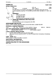
ADC chart of YKBL
 Satellite view of YKBL
Satellite view of YKBL
Sorry, we have no imagery here.
Sorry, we have no imagery here.
Sorry, we have no imagery here.
Sorry, we have no imagery here.
Sorry, we have no imagery here.
Sorry, we have no imagery here.


YKBL - Kambalda
Located in Kambalda, Australia
ICAO - YKBL, IATA - KDB
Data provided by AirmateGeneral information
Coordinates: S31°11'24" E121°35'52"
Elevation is 1059 feet MSL.
Magnetic variation is 1° East View others Airports in Western Australia
Operational data
Special qualification required
Current time UTC:
Current local time:
Weather at : YPKG - Kalgoorlie-Boulder ( 46 km )
TAF: TAF YPKG 062328Z 0700/0800 04012KT CAVOK FM070100 36014KT CAVOK FM071200 18008KT CAVOK
Communications frequencies: [VIEW]
Runways:
| RWY identifier | QFU | Length (ft) | Width (ft) | Surface | LDA (ft) |
| 16 | 164° | 5905 | 98 | X | |
| 34 | 344° | 5905 | 98 | X |
Airport contact information
Address: Kambalda Australia
Satellite view of YKBL
Sorry, we have no imagery here.
Sorry, we have no imagery here.
Sorry, we have no imagery here.
Sorry, we have no imagery here.
Sorry, we have no imagery here.
Sorry, we have no imagery here.