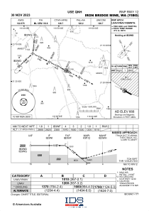
IAC chart of YIBO
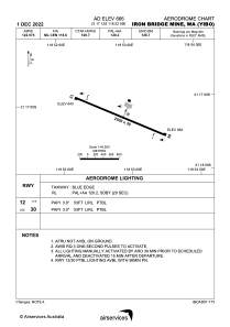
 ADC chart of YIBO
 Satellite view of YIBO
ADC chart of YIBO
Satellite view of YIBO
Sorry, we have no imagery here.
Sorry, we have no imagery here.
Sorry, we have no imagery here.
Sorry, we have no imagery here.
Sorry, we have no imagery here.
Sorry, we have no imagery here.


YIBO - Iron Bridge Mine
Located in Japal Camp, Australia
ICAO - , IATA - IBM
Data provided by AirmateGeneral information
Coordinates: S21°17'12" E118°52'59"
Elevation is 665 feet MSL.
View others Airports in Western Australia
Operational data
Special qualification required
Current time UTC:
Current local time:
Weather at : - ( 0 km )
METAR: CYYJ 062333Z VRB02KT 12SM -RA FEW009 FEW014 BKN032 OVC048 11/10 A2993 RMK SF1SC2SC4SC2 SF TR PRESFR SLP138
Communications frequencies: [VIEW]
Runways:
| RWY identifier | QFU | Length (ft) | Width (ft) | Surface | LDA (ft) |
| 12 | 116° | 8202 | 98 | UNK | |
| 30 | 296° | 8202 | 98 | UNK |
Airport contact information
Address: Japal Camp Australia
Satellite view of YIBO
Sorry, we have no imagery here.
Sorry, we have no imagery here.
Sorry, we have no imagery here.
Sorry, we have no imagery here.
Sorry, we have no imagery here.
Sorry, we have no imagery here.