ADC chart of YGLS
 Satellite view of YGLS
Satellite view of YGLS
Sorry, we have no imagery here.
Sorry, we have no imagery here.
Sorry, we have no imagery here.
Sorry, we have no imagery here.
Sorry, we have no imagery here.
Sorry, we have no imagery here.


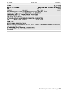
YGLS - Giles
Located in Alice Springs, Australia
ICAO - YGLS, IATA -
Data provided by AirmateGeneral information
Coordinates: S25°3'0" E128°18'0"
Elevation is 579 feet MSL.
View others Airports in Western Australia
Operational data
Special qualification required
Current time UTC:
Current local time:
Weather at : - ( 0 km )
METAR: SKBG 061043Z 17009KT 9999 SCT050 20/17 Q1014
Communications frequencies: [VIEW]
Runways:
| RWY identifier | QFU | Length (ft) | Width (ft) | Surface | LDA (ft) |
| 12 | 0° | 5249 | 0 | X | |
| 30 | 0° | 5249 | 0 | X |
Airport contact information
Address: Alice Springs Australia
Satellite view of YGLS
Sorry, we have no imagery here.
Sorry, we have no imagery here.
Sorry, we have no imagery here.
Sorry, we have no imagery here.
Sorry, we have no imagery here.
Sorry, we have no imagery here.