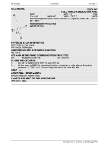
ADC chart of YGIL
 Satellite view of YGIL
Satellite view of YGIL
Sorry, we have no imagery here.
Sorry, we have no imagery here.
Sorry, we have no imagery here.
Sorry, we have no imagery here.
Sorry, we have no imagery here.
Sorry, we have no imagery here.


YGIL - Gilgandra
Located in Gilgandra, Australia
ICAO - YGIL, IATA -
Data provided by AirmateGeneral information
Coordinates: S31°41'49" E148°38'11"
Elevation is 1050 feet MSL.
Magnetic variation is 11° East View others Airports in New South Wales
Operational data
Special qualification required
Current time UTC:
Current local time:
Weather at : YSDU - Dubbo ( 58 km )
TAF: TAF YSDU 070506Z 0706/0800 24012KT CAVOK FM070800 20008KT CAVOK FM071300 16005KT CAVOK FM072100 11007KT CAVOK
Communications frequencies: [VIEW]
Runways:
| RWY identifier | QFU | Length (ft) | Width (ft) | Surface | LDA (ft) |
| 15 | 0° | 4206 | 0 | X | |
| 33 | 0° | 4206 | 0 | X | |
| 08 | 0° | 1902 | 0 | S | |
| 26 | 0° | 1902 | 0 | S |
Airport contact information
Address: Gilgandra Australia
Satellite view of YGIL
Sorry, we have no imagery here.
Sorry, we have no imagery here.
Sorry, we have no imagery here.
Sorry, we have no imagery here.
Sorry, we have no imagery here.
Sorry, we have no imagery here.