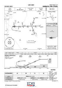
IAC chart of YGIA
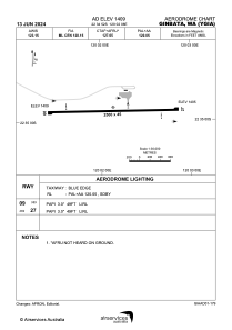
 ADC chart of YGIA
 Satellite view of YGIA
ADC chart of YGIA
Satellite view of YGIA
Sorry, we have no imagery here.
Sorry, we have no imagery here.
Sorry, we have no imagery here.
Sorry, we have no imagery here.
Sorry, we have no imagery here.


YGIA - Ginbata
Located in Roy Hill Camp, Australia
ICAO - , IATA - GBW
Data provided by AirmateGeneral information
Coordinates: S22°34'52" E120°2'8"
Elevation is 1409 feet MSL.
View others Airports in Western Australia
Operational data
Special qualification required
Current time UTC:
Current local time:
Weather at : - ( 0 km )
METAR: KXVG 071633Z AUTO 32007KT 264V004 10SM CLR M04/M14 A3024 RMK AO2
Communications frequencies: [VIEW]
Runways:
| RWY identifier | QFU | Length (ft) | Width (ft) | Surface | LDA (ft) |
| 09 | 90° | 8202 | 148 | UNK | |
| 27 | 270° | 8202 | 148 | UNK |
Airport contact information
Address: Roy Hill Camp Australia
Satellite view of YGIA
Sorry, we have no imagery here.
Sorry, we have no imagery here.
Sorry, we have no imagery here.
Sorry, we have no imagery here.
Sorry, we have no imagery here.