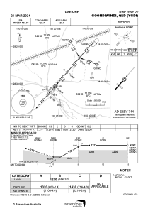
IAC chart of YGDI
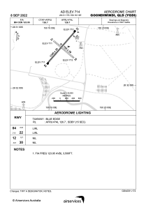
 ADC chart of YGDI
 Satellite view of YGDI
ADC chart of YGDI
Satellite view of YGDI
Sorry, we have no imagery here.
Sorry, we have no imagery here.
Sorry, we have no imagery here.
Sorry, we have no imagery here.
Sorry, we have no imagery here.
Sorry, we have no imagery here.


YGDI - Goondiwindi
Located in Goondiwindi, Australia
ICAO - YGDI, IATA - GOO
Data provided by AirmateGeneral information
Coordinates: S28°31'17" E150°19'13"
Elevation is 714 feet MSL.
View others Airports in Queensland
Operational data
Special qualification required
Current time UTC:
Current local time:
Weather at : - ( 0 km )
METAR: TXKF 022155Z 05009KT 9999 SCT013 BKN030 BKN300 20/18 Q1026
Communications frequencies: [VIEW]
Runways:
| RWY identifier | QFU | Length (ft) | Width (ft) | Surface | LDA (ft) |
| 04 | 42° | 4396 | 98 | ASP | |
| 22 | 222° | 4396 | 98 | ASP | |
| 12 | 131° | 2608 | 98 | CLA | |
| 30 | 311° | 2608 | 98 | CLA |
Airport contact information
Address: Goondiwindi Australia
Other aviation service providers
Aviation club (not for profit)

Satellite view of YGDI
Sorry, we have no imagery here.
Sorry, we have no imagery here.
Sorry, we have no imagery here.
Sorry, we have no imagery here.
Sorry, we have no imagery here.
Sorry, we have no imagery here.