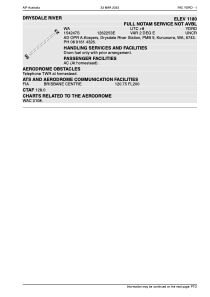
ADC chart of YDRD
 Satellite view of YDRD
Satellite view of YDRD
Sorry, we have no imagery here.
Sorry, we have no imagery here.
Sorry, we have no imagery here.
Sorry, we have no imagery here.
Sorry, we have no imagery here.
Sorry, we have no imagery here.


YDRD - Drysdale River
Located in Wyndham, Australia
ICAO - YDRD, IATA - DRY
Data provided by AirmateGeneral information
Coordinates: S15°42'47" E126°22'53"
Elevation is 1268 feet MSL.
Magnetic variation is 2° East View others Airports in Western Australia
Operational data
Special qualification required
Current time UTC:
Current local time:
Weather at : - ( 0 km )
METAR: ZMUB 080800Z 36006MPS 320V040 9999 FEW033 15/M13 Q1012 NOSIG RMK QFE651.9 14 MOP
Communications frequencies: [VIEW]
Runways:
| RWY identifier | QFU | Length (ft) | Width (ft) | Surface | LDA (ft) |
| 05 | 0° | 4589 | 0 | G | |
| 23 | 0° | 4589 | 0 | G |
Airport contact information
Address: Wyndham Australia
Satellite view of YDRD
Sorry, we have no imagery here.
Sorry, we have no imagery here.
Sorry, we have no imagery here.
Sorry, we have no imagery here.
Sorry, we have no imagery here.
Sorry, we have no imagery here.