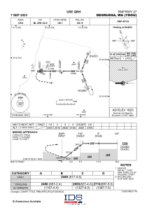
IAC chart of YDGU
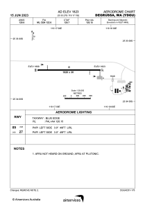
 ADC chart of YDGU
 Satellite view of YDGU
ADC chart of YDGU
Satellite view of YDGU
Sorry, we have no imagery here.
Sorry, we have no imagery here.
Sorry, we have no imagery here.
Sorry, we have no imagery here.
Sorry, we have no imagery here.
Sorry, we have no imagery here.


YDGU - Degrussa
Located in Degrussa Village, Australia
ICAO - , IATA -
Data provided by AirmateGeneral information
Coordinates: S25°33'27" E119°17'15"
Elevation is 1823 feet MSL.
View others Airports in Western Australia
Operational data
Special qualification required
Current time UTC:
Current local time:
Weather at : - ( 0 km )
METAR: KXER 071710Z AUTO VRB05KT 10SM 18/13 A2998 RMK A01
Communications frequencies: [VIEW]
Runways:
| RWY identifier | QFU | Length (ft) | Width (ft) | Surface | LDA (ft) |
| 09 | 89° | 6299 | 98 | UNK | |
| 27 | 269° | 6299 | 98 | UNK |
Airport contact information
Address: Degrussa Village Australia
Satellite view of YDGU
Sorry, we have no imagery here.
Sorry, we have no imagery here.
Sorry, we have no imagery here.
Sorry, we have no imagery here.
Sorry, we have no imagery here.
Sorry, we have no imagery here.