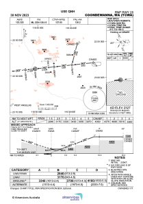
IAC chart of YCWA
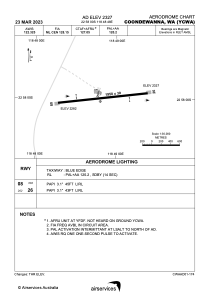
 ADC chart of YCWA
 Satellite view of YCWA
ADC chart of YCWA
Satellite view of YCWA
Sorry, we have no imagery here.
Sorry, we have no imagery here.
Sorry, we have no imagery here.
Sorry, we have no imagery here.
Sorry, we have no imagery here.
Sorry, we have no imagery here.


YCWA - Coondewanna
Located in Coondewanna Mining Camp, Australia
ICAO - YCWA, IATA - CJF
Data provided by AirmateGeneral information
Coordinates: S22°57'60" E118°48'48"
Elevation is 2327 feet MSL.
View others Airports in Western Australia
Operational data
Special qualification required
Current time UTC:
Current local time:
Weather at : - ( 0 km )
METAR: KTGI 070555Z AUTO 10SM OVC110 13/10 A2982 RMK AO1 T01330100 10230 20024
Communications frequencies: [VIEW]
Runways:
| RWY identifier | QFU | Length (ft) | Width (ft) | Surface | LDA (ft) |
| 08 | 83° | 6824 | 98 | UNK | |
| 26 | 263° | 6824 | 98 | UNK |
Airport contact information
Address: Coondewanna Mining Camp Australia
Satellite view of YCWA
Sorry, we have no imagery here.
Sorry, we have no imagery here.
Sorry, we have no imagery here.
Sorry, we have no imagery here.
Sorry, we have no imagery here.
Sorry, we have no imagery here.