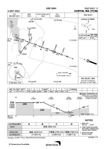
IAC chart of YCIN
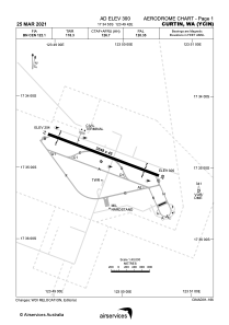
 ADC chart of YCIN
 Satellite view of YCIN
ADC chart of YCIN
Satellite view of YCIN
Sorry, we have no imagery here.
Sorry, we have no imagery here.
Sorry, we have no imagery here.
Sorry, we have no imagery here.
Sorry, we have no imagery here.
Sorry, we have no imagery here.


YCIN - Curtin
Located in Derby, Australia
ICAO - YCIN, IATA - DCN
Data provided by AirmateGeneral information
Coordinates: S17°34'53" E123°49'42"
Elevation is 300 feet MSL.
View others Airports in Western Australia
Operational data
Special qualification required
Current time UTC:
Current local time:
Weather
METAR: YCIN 070400Z AUTO 18003KT 9999 // NCD 32/24 Q1012
Communications frequencies: [VIEW]
Runways:
| RWY identifier | QFU | Length (ft) | Width (ft) | Surface | LDA (ft) |
| 11 | 110° | 10003 | 148 | ASP | |
| 29 | 290° | 10003 | 148 | ASP |
Airport contact information
Address: Derby Australia
Satellite view of YCIN
Sorry, we have no imagery here.
Sorry, we have no imagery here.
Sorry, we have no imagery here.
Sorry, we have no imagery here.
Sorry, we have no imagery here.
Sorry, we have no imagery here.