ADC chart of YBYI
 Satellite view of YBYI
Satellite view of YBYI
Sorry, we have no imagery here.
Sorry, we have no imagery here.
Sorry, we have no imagery here.
Sorry, we have no imagery here.
Sorry, we have no imagery here.
Sorry, we have no imagery here.


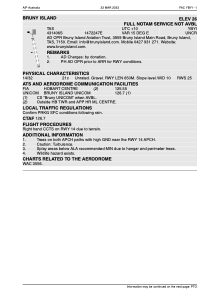
YBYI - Bruny Island
Located in Great Bay, Australia
ICAO - YBYI, IATA -
Data provided by AirmateGeneral information
Coordinates: S43°14'6" E147°22'47"
Elevation is 50 feet MSL.
Magnetic variation is 15° East View others Airports in South Australia
Operational data
Special qualification required
Current time UTC:
Current local time:
Weather at : YMHB - Hobart ( 46 km )
METAR: YMHB 081200Z AUTO 33004KT 9999 // NCD 10/09 Q1022
TAF: TAF YMHB 081105Z 0812/0912 33006KT 9999 FEW040 BECMG 0903/0905 14006KT CAVOK BECMG 0909/0911 33006KT CAVOK
Communications frequencies: [VIEW]
Runways:
| RWY identifier | QFU | Length (ft) | Width (ft) | Surface | LDA (ft) |
| 14 | 152° | 2119 | 91 | DIRT | |
| 32 | 332° | 2119 | 91 | DIRT |
Airport contact information
Address: Great Bay Australia
Satellite view of YBYI
Sorry, we have no imagery here.
Sorry, we have no imagery here.
Sorry, we have no imagery here.
Sorry, we have no imagery here.
Sorry, we have no imagery here.
Sorry, we have no imagery here.